Waterfalls of the Oregon Cascades
The blog has been languishing lately and in the age of Social Media I am thinking the blog is possibly a better vehicle for documenting my hikes for myself and sharing with family/friends than social media. I prefer full control over image resolution and the content formatting and anyone with a phone or computer can view a website. So I’ve decided to invest time in the blog to document my photography equipment experiences/reviews and outdoor adventures.
I had been eyeing the Highway 138 Corridor for years and finally planned a trip around visiting it. Figured I would hit numerous falls on my way there and make a pit stop into Crater Lake. It was a mostly succesful journey, but I did have to make some last minute adjustements. A fellow photographer informed me my first night out that the road to Proxy falls, Linton Falls and Scott LAke had just been closed earlier in the day. This was my intended stop on night 1, so I was already making adjustments. Later in the journey on day 2 I met a roadblock and a guard who wouldn’t allow me to continue the last 200 yards to the Warm Springs Falls trailhead. That is September in Oregon I suppose and in retrospect my agenda was already so full I was already pushing the limits of the daylight I had and my bodies ability to cover the mileage. I sacrified calorie intake for trail time trying to check every fall off the list and by the end of day 2 could really feel the calorie deficit hitting my energy level, but I managed to walk most of every waking hour for 48 hours.
The Stats
From 7am Wedesnday until 7pm Thurday my Garmin watch claims I ….
- Walked 24 miles
- Ascended 4,5000 feet
- Burned 7,900 calories
16 of the miles and 3,000 feet of elevation were on Wedensday alone. Thursday involved more time on the road traveling between trails which wound up being a good thing as my legs were spent and I struggled the last couple falls of the day.
Day 0 - Koosah And Sahalie Falls
I drove out Tuesday late afternoon and managed to hit Sahale/Koosah falls. This is where I learned proxy was closed so I decided to stay at Clear Lake for the night which is a mere 1/4 mile from the falls trailhead.

Above: Sahalie Falls

Above: Sahalie Falls

Above: Sahalie Falls

Above: Small cascades on the McKenzie river above Sahalie Falls

Above: Koosah Falls

Above: Koosah Falls
Above: McKenzie River Above: Smaller 5-10’ Cascades on the McKenzie.

I’m always mesmerized by how blue the water along the McKenzie is.

Above: An unnamed cascade along the McKenzie River
Day 1
This was the official start of my waterfall tour. I started the morning at 5:30am driving to the Marion Lake Trailhead.
Marion and Gatch falls
According to NW Waterfall Survey, both of these are roughly 75’ drops. They occurs in very close proximity and you can view both cascades form a single vantage point. Marion is fairly accesible alone and you can hike down to the base, but there is no safe/easy way to get to the bottom of Gatch.
On the way to the falls you pass Ann Lake, which today was already giving off some early season fall vibes. Some photos I snapped on the return from the falls.

Above: Ann Lake

Above: Ann Lake and some Fall Color

Above: Marrion Falls

Above: Marrion and Gatch Falls

Above: Tight View of Gatch and Marion
Gooch Falls
Gooch Falls is downstream of Marrion/Gatch on private land. There is a sign informing you “Please use caution to enjoy falls. Entry permit required”. The sign is, however, berfect of any details. The land is for sale (or was up for auction) based on the sign and info on an auction website. Access could be at risk, so enjoy before it’s gone. There is no official trailhead, you just need to park at a gate near the falls and walk up the road until you find a trail behind the auction sign.
This waterfall, at about 110’ tall is not only taller than GAtch falls but signifcantly wider with much more fan out. It’s quite a site in person, but difficult to capture the scale of.

Above: Wide shot of Gooch Falls and surrounding forest.

Above: Slightly tighter view.

Above: Close up of Gooch Falls
Downing Creek falls
Next up I drove to Downing Creek Falls. These is no official trailhead here and the turn is easy to miss. The first few hundred yards of road are one lane. In fact it’s so narrow I had tree branches scraping both sides of my van as soon as I turned off the highway. Out of cuation I immediately parked in a small pullout that is only a few dozen feet up the forest road which can accomodate a couple cars and walked the rest.
I’d seen photos of downing creek, but in person it was next level. Easily the most enchanting waterfall I’ve been to. Every square inch of massive fallen trees across the creek are covered in bright green moss, even in September when it hasn’t rained in months. Water flows out all around the canyon walls, something most wide angle photos dont capture well. Definitely a place i’ll visit again.

Above: Downing Creek Falls

Above: Wider view of Downing Creek Falls

Above: Downing Creek viewed from the hillside on the North bank.
Chush falls
Chush Falls is a wonderful hike despite traversing some burn area. I had intended to hit several additional falls that wdere off trail adventures here, but being the final hike of the day and having limited daylight hours I had to abandon those. I also lost the trail about 1/4 mile before Upper Chush Falls and never managed to get a shot of it. I could see it cascading down above the trees (it’s a tall one), but I was so tired I made the choice to turn back and find a camp site before dark which was the right choice give my depleted energy stores. By the end of this hike I had logged 16 miles for the day between the official hikes I documented above earlier in the day and some random meandering about various creeks.
The light at Chush Falls on arrival was absolutely perfect with rays of sunlight lighting up the spray. In about 5 minutes that sunlight went away and the moment was gone.

Above: Chush Falls and sunlit spray

Above: Sunstar as Chush Falls

Above: SLooking back towards Broken Top on the return from Chush Falls
Day 2
Three Sisters Sunrise
After eating I began driving out from camp, but after a few short miles cames to a nice clearing with views of Broken Top and Three Sisters so I decided to hang out until sunrise.

Above: South Sister at sunrise.

Above: Middle and North Sister at Blue Hour

Above: Broken Top Getting some Morning Light
Tumalo falls
Next stop was Tumalo which I had visited just weeks earlier, but after hiking up stream a ways with the family I missed out on grabbing some shots in nice light from below Tumalo. There are some great falls further upstream though.

Above: Tumalo Falls

Above: Tumalo Falls

Above: Tumalo Falls
Paulina falls
I had been to Paulina in late September 2021 and actually hiked through some snow to see it. Weather was a bit different on this September day with temps in the 70s.
Paulina falls into a large amphitheatre from two separate cascades that are quite far apart. The scale is difficult to capture, the boulder in the amphitheatre are the size of vehicles.

Above: Paulina Falls

Above: Closeup of the Northern cascade at Paulina Falls
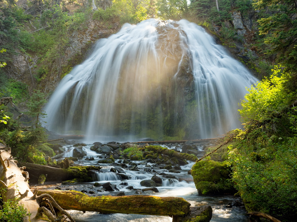
Lemolo falls
Lemolo Falls is more hike than I had expected. After a fairly busy 16 miles and 3k feet of ascent on day 1 I was relatively tired already. I began the Lemolo hike forgetting to check the elevation of the hike only noticing it was just a few miles round trip. Turns out it’s 700 feet down which would normally not phase me, but I had also eschewed my trekking poles givne how short the hike was. I also carried all my camera gear. The hike back up was grueling with my legs somewhat sore, but it was worth it as Lemolo is definitely in my top 10 favorite falls, maybe top 5. I love waterfalls you approach from below and far away and that come into view all of a sudden showing their glory.

Above: First view of Lemolo

Above: Full view of the Falls

Above: Self Portrait of me at the base
That ‘self portrait’ was a good 90-120 second walk from my camera and taken at a relatively long focal length. I triggered the camera via bluetooth.

Above: Same view without the photographer
Toketee falls
I’ve seen so many photos of this one and expectations were high. In person though, this waterfall is simply not very impressive, but it is very photogenic with the basalt column walls around it. Climbing down to the bottom is also quite fun.
Above: Toketee from viewing platform Above: Toketee from the base

Watson falls
Watson Falls has a fairly large day use parking but only a few cars were there. The flow rate of the fall was quite low, but it is very tall. I would recommend visiting this one in Spring.

Above: Self Portrait at Watson
Crater Lake Sunset
TO end the day I drove into Crater Lake to catch sunset, which I thought would be great given the clouds. I did get some nice color but it never quite shows up over the lake.
Above: The famous Whitebark Pine at Merriam Point Above: The famous Whitebark Pine at Merriam Point Above: The famous Whitebark Pine at Merriam Point Above: Pink sunset light hitting the Caldera Walls Above: Last Light Hitting Wizard Island Above: View from Merriam Point out towards the cascades


Day 3
Crater Lake Sunrise
Sunrise was a mild disappointment. The light never quite made it through the clouds on the horizon, but it was a beautiful calm morning.

Above: The Whitebark Pine just after sunrise

Above: The Whitebark Pine just after sunrise
Salt Creek falls
Finally began the drive home, but hit Salt Creek Falls on the way. My last stop here i viewed it only from the top before hiking down to Diamond Creek Falls. A maple near the bottom of the trail was turning color already which made for a wonderful end of my adventure.

Above: Salt Creek Falls