Fall in Gifford Pinchot National Forest
I attempted to get to Paradise around peak autumn color again this year, hoping to capture it with color similar to my fall 2024 trip which was perfectully timed, but capture some new perspectives. I planned this trip a few months in advance and an early morning fall storm rolled in which impacted my plans and made me adjust at the last minute.
Ultimately I wound up spending the first 24 hours of this trip around Mount Adams, which was wonderful. I could see from the slopes of Adams above the trees that first day that Rainier was clouded in, so it was a good choice. I used the time to hike up to High camp and explore some new areas around the Mountain I’ve not yet been too.
The Stats
Stats from Friday through Sunday.
- Walked 31 miles
- Ascended 6,0000 feet
- Burned 10,153 calories
Day 1
Arrived in Gifford Pinchot near Adams a few hours before sunset. Mostly putzed around exploring and scoping out new spots in the rain with no mountain views or light breaking through.
My luck did change a bit closer to sunset when there were a few brief cloud breaks that let in some light. I got a nice timelapse late afternoon before sunset.
Also got a nice large cloud break over the lake which offered a faint rainbow.

Above: Fain rainbow appears over the lake during a brief late afternoon cloud break.
Throughout sunset the Adams stayed hidden, before finally making a partial appearance moments after sunset bathed in alpenglow.

Above: Adams visible during a breief cloud break
Day 2
Sunrise
Sunrise was largely a bust. I hung around the lake about an hour catching only a small bit of light illuminating the fog.

Above: Warm sunrise light hitting fog over the lake.

Above: Fog floating across the surface of Takhlakh Lake
I finally decided to make my way to the Muddy Meadows trailhead hoping for better conditions there. While driving through dense fog with limited visibility the sun suddenly out near Takh Takh Meadow. I stopp the car and jumped out to snap a few shots before the Mountain disappeared behind fog about 60 seconds later.

Above: Adams, a meadow and fog in warm early morning sunlight.

Above: Fast moving fog quickly shrouded the mountain within a minute.

Above: Another meadow just a ways up the road sporting some color.

Above: Another area in the previous meadow after some fog lifted.
Killen Creek to High Camp
Muddy Meadows was a bust with no more cloud breaks occuring, so I decided to head to Killen Creek TH. My original intent was to hike to Kill Creek Meadows, an area I had visited before. The mountain really cleared up though once I had ascended to the first meadow on the trail and decided instead I would ascend all the way to High Camp. The fresh blanket of snow was just too inviting to not continue climbing.
Above: Second Meadow on the Killen Creek Trail. Above: More Meadow Mountain Views. Above: Another area in the More Meadow Mountain Views. Above: Up the ridge to the first glacier. Above: Mountain in full view just before High Camp. Above: Telephoto view of the Glaciers and fresh blanket of snow.


Muddy Meadows
I went back to Muddy Meadows after thinking I might get some great conditions for a time lapse. The mountain didn’t make a complete appearance but the light cascading across the meadow and slopes of Adams I found quite nice.
Paradiise
The forecast had called for a clear day Saturday so I decided I would head to Rainier for the night so I could wake up early to hike. I got gas and checked the forecast in Packwood. The NWS point forecast suggested 40% chance of rain tomorrow at various points in the 4-7k feet elevation ranges around Rainier. By the time I arrived at camp site near the park it was starting to sprinkle. It rained off and on all night despite the forecast, and even though I held hope for Saturday to be partly to mostly sunny it ended up raining and being drizzly the entire day. My hopes of a repeat of my 2024 trip were dashed. I decided after spending the early morning at Paradise I would spend the remaindr of the day visiting and hiking waterfalls and lakes.
Above: View from above Myrtle Falls, Rainier is top of the frame if you imagine hard enough. Above: Fall color at Paradise. Above: Dense fog at Paradise. Above: Paradise River. Above: Above Narada Falls. Above: Narada Falls . Above: Christine Falls Above: Martha Falls Above: Washington Cascades on the Paradise River Above: The bottom tier of Ruby Falls. Above: Fall color above Louise Lake . Above: Fall color above Unicorn Creek .


Tipsoo Lake Sunset
After many hours of walking around the Paradise region I drove to Tipsoo hoping the mountain would make an appearance at sunset. It made a partial appearance at least.
Above: Slopes of Naches covered in Autumn Color. Above: Tipsoo Lake at Sunset. Above: Long Exposure shortly after sunset. Above: Yakima Peak in late afternoon light.


Tipsoo Sunrise and Naches Loop
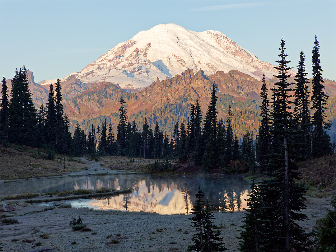
I was convinced the low pressure bringing all the rain would finally move out based on the clearing I began seeing at sunset, so I planned to be at Tipsoo again for sunrise. MY original plan was to hike up Pinnacle Peak this morning but I had not hiked Naches ever and figured I could get a great sunrise at Tipsoo then immediatley knock out Naches and be home at a reasonable time. Sunrise didn’t disappoint!
Above: Rainier and Tipsoo with some pink clouds. Above: Morning light beginning to hit Rainier Above: Rainier and surrounding sub peaks bathed in the morning sun. Above: Rainier perfectly reflected in Upper Tipsoo. Above: Rainier and Upper Tipsoo. Above: Frost tipped fall foliage above Upper Tipsoo.


I did Naches ‘backwards’, starting from Upper Tipsoo which required me to turn around and look at Rainier rather than having it constantly in view. However, I wanted to capture photos from the tarns above before the light got harsh.
Above: Rainier from Naches. Above: Rainier above the tarn on Naches. Above: Intense Fall color along parts of the trail. Above: Fall color and some remaining wildfire smoke out to the east. Above: Tarns on the east side of the loop. Above: Final mid morning view of Tipsoo and Rainier.


